
The Grand Canyon
Microsoft® Encarta® Encyclopedia 99. © 1993-1998 Microsoft Corporation.
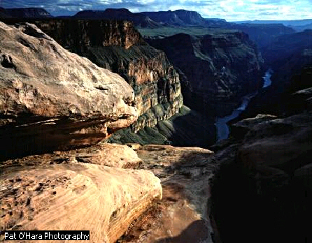
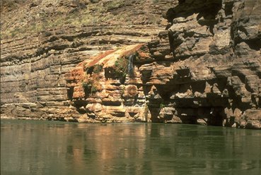
This rock
formation, known as "The Alligator," is part of the
enormous expanse of Arizona's world-famous Grand Canyon. The canyon,
carved by the Colorado River, stretches 277 miles across the state's
Colorado Plateau and reaches a maximum width of 18 miles. Beautiful
rock formations of layered limestone, sandstone, shale, and other
rock rise from the canyon floor, which is more than 5000 feet below
the canyon rim.
Colors in the layers of rock in the Grand Canyon change dramatically during the course of a day. Shades of red and brown intensify at sunset.
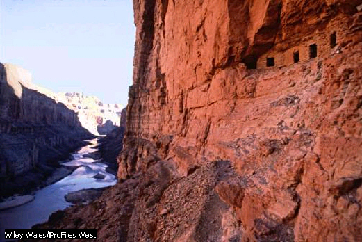
The Anasazi built impressive cliff dwellings in the Grand Canyon. These granaries were discovered in Marble Canyon of Grand Canyon National Park in northwestern Arizona.
Wiley Wales/ProFiles West
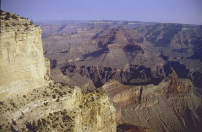
The Grand Canyon is an exceptionally deep, steep-walled canyon in northwestern Arizona, excavated by the Colorado River. The Grand Canyon is 446 km (277 mi) long, up to 29 km (18 mi) wide, and more than 1500 m (5000 ft) deep. The entire canyon is extremely beautiful, containing towering buttes, mesas, and valleys within its main gorge. A spectacular section of the canyon, together with plateau areas on either side of it, are preserved as the Grand Canyon National Park, which receives about four million visitors a year.
 The
Grand Canyon cuts steeply through an arid plateau region that lies
between about 5000 and 9000 feet above sea level. This region,
although lacking year-round streams in recent years, is sharply
eroded, showing such characteristic forms as buttes; it is
interspersed with old lava flows, hills composed of volcanic debris,
and intrusions of igneous rock. The plateau area has a general
downward slope to the southwest and in its upper reaches is sparsely
covered with such evergreens as juniper and piñon. Parts of
the northern rim of the canyon are forested. Vegetation in the depths
of the valley consists principally of such desert plants as agave and
Spanish bayonet. In general the entire canyon area has little soil.
The climate of the plateau region above the canyon is severe, with
extremes of both heat and cold. The canyon floor also becomes
extremely hot in summer, but seldom experiences frost in the wintertime.
The
Grand Canyon cuts steeply through an arid plateau region that lies
between about 5000 and 9000 feet above sea level. This region,
although lacking year-round streams in recent years, is sharply
eroded, showing such characteristic forms as buttes; it is
interspersed with old lava flows, hills composed of volcanic debris,
and intrusions of igneous rock. The plateau area has a general
downward slope to the southwest and in its upper reaches is sparsely
covered with such evergreens as juniper and piñon. Parts of
the northern rim of the canyon are forested. Vegetation in the depths
of the valley consists principally of such desert plants as agave and
Spanish bayonet. In general the entire canyon area has little soil.
The climate of the plateau region above the canyon is severe, with
extremes of both heat and cold. The canyon floor also becomes
extremely hot in summer, but seldom experiences frost in the wintertime.
The Grand Canyon has been sculpted in general by the downward cutting
of the Colorado River, which flows through the canyon's lowest
portions. Other factors have also played a part. The Kaibab Plateau, which forms the northern
rim of the canyon, is about 1200 feet higher than the Coconino
Plateau, which forms the southern rim. Water from the northern side
has flowed into the canyon, forming tributary valleys, while the
streams of the southern plateau flow away in a southerly direction
without carving valleys in the canyon walls. The underlying rock beds
also have a southwestern slant, with the result that groundwater from
the north finds its way into the canyon, but water from the south
does not. In the entire canyon region, the rocks have been broken by
jointing and faulting, and fractures in the rocks resulting from
these processes have contributed to the rapid erosion of the gorge.
have also played a part. The Kaibab Plateau, which forms the northern
rim of the canyon, is about 1200 feet higher than the Coconino
Plateau, which forms the southern rim. Water from the northern side
has flowed into the canyon, forming tributary valleys, while the
streams of the southern plateau flow away in a southerly direction
without carving valleys in the canyon walls. The underlying rock beds
also have a southwestern slant, with the result that groundwater from
the north finds its way into the canyon, but water from the south
does not. In the entire canyon region, the rocks have been broken by
jointing and faulting, and fractures in the rocks resulting from
these processes have contributed to the rapid erosion of the gorge.
The Grand Canyon is of relatively recent origin; apparently the river began its work of erosion about six million years ago. Coupled with the downward cutting of the river has been a general rising or upwarping of the Colorado Plateau, which has added its effect to the action of the river.
Although the canyon itself is of comparatively recent origin, the rocks exposed in its walls are not. Most of the strata were originally deposited as marine sediment, indicating that for long periods of time the canyon area was the floor of a shallow sea.
 In
a typical section of the canyon, toward its eastern end, nine
separate rock layers can be seen, piled vertically like a stack of
pancakes. The topmost layer is a limestone, the Kaibab limestone.
Below this layer is a thick deposit of sandstone, called the Coconino
sandstone, and below that a layer of soft, shaly rock known as the
Hermit shale. Still lower is a series of shales and sandstones
interbedded with each other, collectively termed the Supai formation.
The fossils found in the Supai and the rocks above it suggest that
these rocks were all deposited in the Permian Period, at the end of
the Paleozoic Era, from 225 million to 280 million years ago.
However, the Supai may be slightly older still. Next comes a deposit
of light gray-blue limestone, the Redwall limestone, which in many
places has been colored red by seepage from the Supai beds above. The
Redwall is 152 m (500 ft) thick and is easily identified because of
the prominent sheer cliffs that it forms in the canyon walls. This
layer has been identified as belonging to the Mississippian Period
and was laid down more 280 million years ago. A thin layer of
sandstone, the Temple Butte, beneath the Redwall, gives evidence of
having originated in the Devonian Period, about 345 million to 395
million years ago. The next three rock layers, consisting of the
brown Muav limestone, the green Bright Angel shale, and the Tapeats
sandstone, all belong to the Cambrian Period, at the dawn of the
Paleozoic Era, from 500 million to 570 million years ago. Beneath
these layers, at the bottom of the canyon, are the most ancient rocks
of all, Precambrian schists and gneisses, from half a billion to a
billion years old.
In
a typical section of the canyon, toward its eastern end, nine
separate rock layers can be seen, piled vertically like a stack of
pancakes. The topmost layer is a limestone, the Kaibab limestone.
Below this layer is a thick deposit of sandstone, called the Coconino
sandstone, and below that a layer of soft, shaly rock known as the
Hermit shale. Still lower is a series of shales and sandstones
interbedded with each other, collectively termed the Supai formation.
The fossils found in the Supai and the rocks above it suggest that
these rocks were all deposited in the Permian Period, at the end of
the Paleozoic Era, from 225 million to 280 million years ago.
However, the Supai may be slightly older still. Next comes a deposit
of light gray-blue limestone, the Redwall limestone, which in many
places has been colored red by seepage from the Supai beds above. The
Redwall is 152 m (500 ft) thick and is easily identified because of
the prominent sheer cliffs that it forms in the canyon walls. This
layer has been identified as belonging to the Mississippian Period
and was laid down more 280 million years ago. A thin layer of
sandstone, the Temple Butte, beneath the Redwall, gives evidence of
having originated in the Devonian Period, about 345 million to 395
million years ago. The next three rock layers, consisting of the
brown Muav limestone, the green Bright Angel shale, and the Tapeats
sandstone, all belong to the Cambrian Period, at the dawn of the
Paleozoic Era, from 500 million to 570 million years ago. Beneath
these layers, at the bottom of the canyon, are the most ancient rocks
of all, Precambrian schists and gneisses, from half a billion to a
billion years old.
The first Europeans to see the canyon were members of a group
headed by the Spanish explorer Francisco Vásquez de Coronado,
which set out from New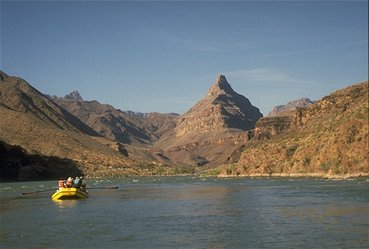 Spain (now Mexico) in February 1540. The sighting was made later that
year. Because of the inaccessibility of the canyon, it was not until
more than three centuries later that it was fully explored. Beginning
about 1850, a series of expeditions commanded by officers of the
United States Army surveyed the canyon and the surrounding area. The
first passage of the canyon was accomplished in 1869 by the American
geologist John Wesley Powell and ten companions, who made the
difficult journey through the length of the gorge in four rowboats.
Spain (now Mexico) in February 1540. The sighting was made later that
year. Because of the inaccessibility of the canyon, it was not until
more than three centuries later that it was fully explored. Beginning
about 1850, a series of expeditions commanded by officers of the
United States Army surveyed the canyon and the surrounding area. The
first passage of the canyon was accomplished in 1869 by the American
geologist John Wesley Powell and ten companions, who made the
difficult journey through the length of the gorge in four rowboats.
The construction of the Glen Canyon Dam in Arizona in 1963 dramatically reduced the natural flow of sand and nutrients down the Colorado River and into the Grand Canyon. In March 1996 the federal government released more than 100 billion gallons of water from Glen Canyon Dam. This artificial flood added more than three feet to some beaches and cleared fish spawning grounds of debris and sediment.
Visit: http://www.kaibab.org/home.htm for more pictures and information about the Grand Canyon.