Hurricane
Hurricane is the name applied to migratory tropical cyclones (an area of low atmospheric pressure surrounded by a wind system blowing in a counterclockwise direction.) Hurricanes originate over oceans in certain regions near the equator, particularly in the Caribbean Sea and the Gulf of Mexico. Hurricane-type cyclones in the western Pacific are known as typhoons.

Winds
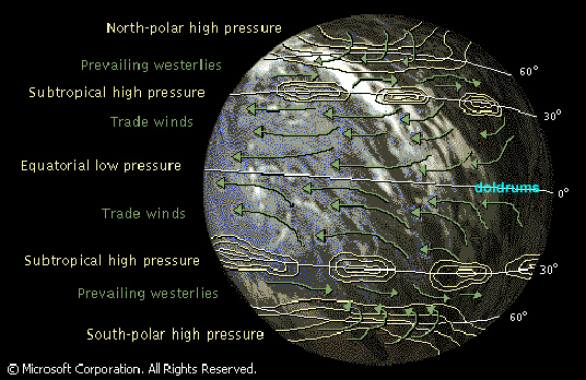
The prevailing winds include northeast and southeast trade winds above and below the equator, prevailing westerlies near the middle latitudes, and polar easterlies near the poles. The winds are named for the direction from which they blow; for example, the northeast trade wind blows in the northern hemisphere from the east toward the west.
Most hurricanes originate within the doldrums, a narrow equatorial belt characterized by intermittent calms, light variable breezes, and frequent squalls, and lying between the northeast and southeast trade winds. As the doldrums of the Atlantic are situated largely to the north of the equator, hurricanes do not occur in the South Atlantic Ocean. The Pacific doldrums extend north and south of the equator; thus hurricanes occur in the South and North Pacific oceans.
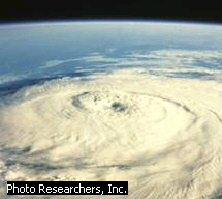
The strongest of a hurricane's thunderstorms occur near the center, or eye, of the cyclone. The eye itself, however, is relatively calm with no thunderstorms and little or no cloud cover.
Hurricanes consist of high-velocity winds blowing circularly around a low-pressure center, known as the eye of the storm. The low-pressure center develops when the warm, saturated air prevalent in the doldrums is under run and forced upward by denser, cooler air. From the edge of the storm toward its center, the atmospheric pressure drops sharply and the wind velocity rises. The winds attain maximum force close to the point of lowest pressure. The diameter of the area affected by winds of destructive force may exceed 150 miles. Gale winds prevail over a larger area, averaging 300 miles in diameter. The strength of a hurricane is rated from 1 to 5. The mildest, Category 1, has winds of at least 74 mph. The strongest (and rarest), Category 5, has winds that exceed 155 mph. Within the eye of the storm, which averages 15 miles in diameter, the winds stop and the clouds lift, but the seas remain very violent.
The air within the eye has a downward, or sinking, motion. Since clouds require rising air to form, they are unable to form within the eye of the cyclone. This is why a blue sky or stars can often be seen from the ground when the eye of a strong hurricane passes overhead.
The sinking air also causes an increase in temperature and a decrease in pressure within the eye, says Dr. Steve Lyons, Hurricane Expert at The Weather Channel. "That warming associated with the sinking causes very rapid pressure falls. That's why once you see an eye forming usually the hurricane is intensifying fairly quickly."
 On
September 2, 1985, Hurricane Elena was photographed with a
70-millimeter lens from the space shuttle Discovery. Because the
hurricane is in the northern hemisphere, the air circles in a
counterclockwise motion toward the low pressure center, or eye.
Photo Researchers, Inc.
In the northern hemisphere the storms usually travel first in a northwesterly direction and in the higher latitudes turn toward the northeast. In the southern hemisphere the usual path of the hurricane is initially to the southwest and subsequently to the southeast. Hurricanes travel at varying rates. In the lower latitudes the rate ranges from 5 to 20 mph and in the higher latitudes it may increase to as much as 50 mph. Those areas in which the hurricane winds blow in the same direction as the general movement of the storm are subjected to the maximum destructive violence of the hurricane.
Improved systems of prediction and communication have been able to help minimize loss of life in hurricanes, but property damage is still heavy, especially in coastal regions. The strongest hurricane to hit the western hemisphere in the 20th century, Gilbert, devastated Jamaica and parts of Mexico in 1988 with winds that gusted up to 218 mph. Destructive hurricanes in recent U.S. history include Agnes (1972), with $3 billion in damage and 134 deaths, Hugo (1989), with more than $4 billion in damage and more than 50 deaths, and Andrew (1992), with an estimated $12 billion in damage, more than 50 dead, and thousands left homeless.
 Since
1943 U.S. military aircraft have been flying into hurricanes to
measure wind velocities and directions, the location and size of the
eye, the pressures within the storms, and their thermal structure. A
coordinated system of tracking hurricanes was developed in the
mid-1950s, and periodic improvements have been made over the years.
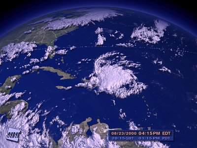
Radar, sea-based recording devices, geosynchronous weather satellites
(since 1966), and other devices now supply data to the National
Hurricane Center in Florida, which follows each storm virtually from
the beginning. The photograph at the left was transmitted from a
weather satellite
These
scientific descriptions make it sound so dull. But there can be no
doubt that living through a Hurricane is a devistating experience.
The following paragraphs are from a news article about the most
severe hurricane the United States has experienced in recorded history.
Horrific Labor Day storm of '35 swept away all but memories
JACKSONVILLE,
Fla. - Bernard Russell felt his sister's grip on his hand pull away
in the darkness as the 200 mph wind whipped his body and waves
crashed over him for what seemed like an eternity.
"You went
wherever the waves pushed you and wherever the winds pushed you,"
he said. "It was so dark, you couldn't see what was going on
and maybe that was good."
A 15-foot-high
wall of water washed over Matecumbe Key. Russell's mother and three
sisters perished, but that was just the beginning.
"There
were 61 in the Russell family and 50 of them died that night,"
Russell, 78, recalled in a recent telephone interview.
The day was
even more terrifying. What became known as the Labor Day hurricane of
1935 cleared every tree and every building off Matecumbe Key, and
destroyed the railroad that connected the Florida Keys to the mainland.
The official
death toll was 423 - 164 civilians and 259 World War I veterans
living in three federal rehabilitation camps.
"There
were so many dead people and no place to take them," said
Russell, who was 17 when the hurricane hit. "They stacked them
up and burned them."
The National
Hurricane Center says that storm was the strongest to hit the United
States in this century and was the first of two Category 5 hurricanes
to hit the United States since record-keeping began.
Category 5
hurricanes pack sustained wind greater than 155 mph, generate a storm
surge higher than 18 feet and cause catastrophic damage. Camille, the
other Category 5 hurricane, devastated the Mississippi coast in 1969,
leaving 256 dead.
The 1935 storm
may have been the strongest, but it was far from the deadliest. The
hurricane that flattened Galveston, Texas, in 1900 killed 6,000 to
8,000 people.
After the 1935
storm, Ernest Hemingway visited the Keys and wrote about the
destruction in a scathing article titled "Who Killed the
Vets" for New Masses magazine and in a letter to his
editor, Max Perkins.
"We
located 69 bodies where no one had been able to get in. Indian Key
was absolutely swept clean, not a blade of grass," he wrote to
Perkins. "We made five trips with provisions for survivors to
different places but nothing but dead men to eat the grub."
Many of the
victims drowned, some swept into the Gulf of Mexico, others sucked
back into the Atlantic after the 15-foot wave passed. Some people
were literally sandblasted to death.
Russell ended
up on top of a trash pile of trees and other debris. He still doesn't
understand how or why he survived. "Only the good Lord knows
that," he said.
http://www.icsi.net/~pickens/huratc2.shtml
http://www.weather.com/weather_center/special_reports/hurricanes/inside/
The preceding links are great places to find more information about hurricanes in general and current weather conditions.