 California.
Strike-slip faults are usually found along boundaries between two
plates that are sliding past each other.
California.
Strike-slip faults are usually found along boundaries between two
plates that are sliding past each other.EARTHQUAKES
The term earthquake is defined as the shaking of Earth's surface caused by rapid movement of Earth's rocky outer layer. Earthquakes occur when energy stored within the earth, usually in the form of strain in rocks, suddenly releases. This energy is transmitted to the surface of the earth by earthquake waves. The study of earthquakes and the waves they create is called seismology Scientists who study earthquakes are called seismologists.
The destruction an earthquake makes depends on the amount of shaking that occurs. Earthquakes, or seismic tremors, occur at a rate of several hundred per day around the world. A worldwide network of seismographs detect about one million small earthquakes per year. Very large earthquakes, such as the 1964 Alaskan earthquake, which measured 8.6 on the Richter scale and caused millions of dollars in damage, occur worldwide once every few years. Moderate earthquakes, such as the 1989 tremor in Loma Prieta, California, and the 1995 tremor in Kôbe, Japan, occur about 20 times a year. Moderate earthquakes also cause millions of dollars in damage and can harm many people.
By studying the different parts and actions of earthquakes, seismologists learn more about their effects and how to predict and prepare for their ground shaking in order to reduce damage.
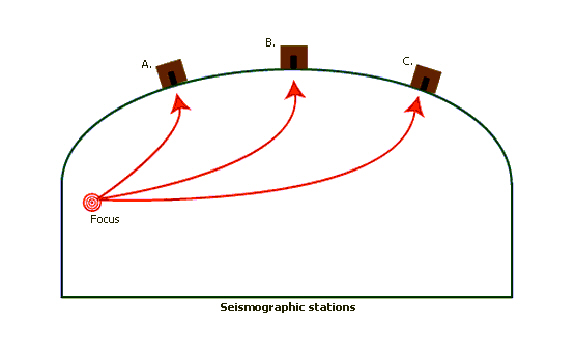
The Difference between the Focus and the Epicenter
The point within the earth where an earthquake originates is called the focus. The point on the earth's surface directly above the focus is called the epicenter. If the focus is near the surface-between 0 and 40 miles deep-shallow-focus earthquakes are produced. If it is intermediate or deep below the crust-between 40 and 400 miles deep-a deep-focus earthquake will be produced. Shallow-focus earthquakes tend to be larger and more damaging. This is because they are closer to the surface where the rocks are stronger and build up more strain.
Seismologists know from observations that most earthquakes originate as shallow-focus earthquakes and most of them occur near plate boundaries-areas where the earth's crustal plates move against each other. Other earthquakes, including deep-focus earthquakes, can originate in subduction zones, where one tectonic plate moves under another plate.
What are Faults?
Stress in the earth's crust creates faults. The properties of an
earthquake depend strongly on the type of movement along the fault.
Geologists categorize faults according to the direction of this
movement. When the rock hanging over the fault slips downward into
the ground, the fault is called a normal fault. When the hanging wall
slips upward in relation to the bottom wall, the fault is called a
thrust fault. Both produce the upward movement of one side of the
fault above the other side. Strike-slip faults are another type of
fault that produce the side by side sliding movement of the fault,
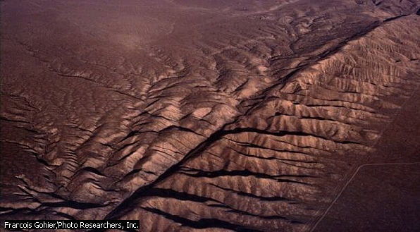
such as seen along the San Andreas fault in California.
Strike-slip faults are usually found along boundaries between two
plates that are sliding past each other.
What are Waves?
The sudden movement of rocks along a fault causes vibrations that transmit energy through the earth in the form of waves. Waves that travel in the rocks below the surface of the earth are called body waves, and there are two types of body waves: primary, or P, waves, and secondary, or S, waves. The S waves cause the most damage during earthquake shaking, as they move the ground back and forth.
Body waves, or P and S waves, radiate out from the rupturing fault starting at the focus of the earthquake. P waves are compression waves because the rocky material in their path moves back and forth in the same direction as the wave travels alternately compressing and expanding the rock. P waves are the fastest seismic waves; they travel in strong rock at about 4 miles per second. P waves are followed by S waves, which shear, or twist, rather than compress the rock they travel through. S waves travel at about 2 miles per second. S waves cause rocky material to move either side to side or up and down depending on the direction the waves are traveling. Both P and S waves help seismologists to locate the focus and epicenter of an earthquake.
Earthquakes also contain surface waves that travel out from the epicenter along the surface of the earth. Two types of these surface waves occur: Rayleigh waves, named after British physicist Lord Rayleigh, and Love waves, named after British geophysicist A. E. H. Love.
Rayleigh waves cause rock particles to move forward, up, backward, and down in a path determined by the direction of the wave travel The Love wave, causes rock to move horizontally, or side to side at right angles to the direction of the traveling wave, with no up or down movement.
WHAT CAUSES EARTHQUAKES?
Most earthquakes are caused by the sudden slip along geologic faults. The faults slip because of movement of the earth's tectonic plates. This concept is called the elastic rebound theory. The rocky tectonic plates move very slowly, floating on top of a weaker rocky layer. As the plates collide with each other or slide past each other, pressure builds up within the rocky crust. Earthquakes occur when pressure within the crust increases slowly over hundreds of years and finally exceeds the strength of the rocks. Earthquakes also occur when human activities, such as the filling of reservoirs, increase stress in the earth's crust.
What is the Elastic Rebound Theory?
In 1911 American seismologist Harry Fielding Reid studied the effects of the April 1906 California earthquake. He proposed the elastic rebound theory to explain the generation of earthquakes that occur in tectonic areas, usually near plate boundaries. This theory states that during an earthquake, the rocks under strain suddenly break, creating a fracture along a fault. When a fault slips, movement in the crustal rock causes vibrations. The slip changes the local strain out into the surrounding rock. The change in strain leads to aftershocks (smaller earthquakes that occur after the initial earthquake), which are produced by further slips of the main fault or adjacent faults in the strained region. The slip begins at the focus and travels along the plane of the fault, radiating waves out along the rupture surface. On each side of the fault, the rock shifts in opposite directions. The fault rupture travels in irregular steps along the fault; these sudden stops and starts of the moving rupture give rise to the vibrations that propagate as seismic waves. After the earthquake, strain begins to build again until it is greater than the forces holding the rocks together, then the fault snaps again and causes another earthquake.
Human Activities can contribute to the cause of earthquakes
Human activities can also be the direct or indirect cause of significant earthquakes. Injecting fluid into deep wells for waste disposal, filling reservoirs with water, and firing underground nuclear test blasts can lead to earthquakes. These activities increase the strain within the rock near the location of the activity so that rock slips and slides along pre-existing faults more easily.
Scientists have determined that as water level in a reservoir increases, water pore pressure inside the rocks along local faults also increases. The increased pressure may cause the rocks to slip, generating earthquakes. Beginning in 1935, the first detailed evidence of reservoir-induced earthquakes came from the filling of Lake Mead behind Hoover Dam on the Nevada-Arizona state border. Earthquakes were rare in the area prior to construction of the dam, but seismographs registered at least 600 shallow-focus earthquakes between 1936 and 1946. Most reservoirs, however, do not cause earthquakes.
HOW OFTEN DO EARTHQUAKES HAPPEN?
Seismologists have been monitoring the frequency and locations of earthquakes for most of the 20th century. They have found that the majority of earthquakes occur along plate tectonic boundaries, while there are relatively few earthquakes that occur within a tectonic plate. Interplate earthquakes are the most common; they happen along plate boundaries. Intraplate earthquakes occur within the plates at places where the crust is fracturing internally. Both interplate and intraplate earthquakes may be caused by tectonic or volcanic forces.
Tectonic Earthquakes
Tectonic earthquakes are caused by the sudden release of energy stored within the rocks along a fault. The released energy is produced by the strain on the rocks due to movement within the earth.
Volcanic Earthquakes
Volcanic earthquakes occur near active volcanoes but have the same fault slip mechanism as tectonic earthquakes. Volcanic earthquakes are caused by the upward movement of magma under the volcano, which strains the rock locally, and leads to an earthquake. Volcanic earthquakes occur in areas that are associated with volcanic eruptions.
WHERE DO EARTHQUAKES HAPPEN?
After studying the worldwide distribution of earthquakes scientists proposed that the shifting of the plates was the main cause of earthquakes. The science of plate tectonics explains the locations of earthquakes, mountain formation, deep ocean trenches, and predict which areas will be damaged the most by earthquakes. Earthquakes within plates, or intraplate tremors, are rare compared with the thousands of earthquakes that occur at plate boundaries each year, but they can be very large and damaging.
Earthquakes that occur in the area surrounding the Pacific Ocean, at the edges of the Pacific plate, are responsible for an average of 80 percent of the energy released in earthquakes worldwide. Japan is shaken by more than 1000 tremors greater than 3.5 in magnitude each year. The western coasts of North and South America are very also active earthquake zones, with several thousand small to moderate earthquakes each year.
Intraplate earthquakes are less frequent than plate boundary earthquakes, but they are still caused by the internal fracturing of rock masses. The New Madrid, Missouri, earthquakes of 1811 and 1812 were extreme examples of intraplate seismic events. Scientists estimate that the three main earthquakes of this series were about magnitude 8.0 and that there were at least 1500 aftershocks.
THE EFFECTS OF EARTHQUAKES
Ground shaking leads to landslides and other soil movement. These are the main damage-causing events that occur during an earthquake. Primary effects that can accompany an earthquake include property damage, loss of lives, fire, and tsunami waves. Secondary effects, such as economic loss, disease, and lack of food and clean water, also occur after a large earthquake.
Ground Shaking and Landslides
Ground shaking weakens soils and foundation materials under structures and causes dramatic changes in fine-grained soils. During an earthquake, water-saturated sandy soil becomes liquid mud, an effect called liquefaction. Shaking may also dislodge large earth and rock masses, producing dangerous landslides, mudslides, and rock avalanches.
Fire
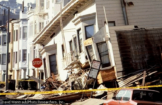
Another post-earthquake threat is fire, such as the fires that happened in San Francisco after the 1906 earthquake and after the devastating 1923 Tokyo earthquake. In the 1923 earthquake, about 130,000 lives were lost in Tokyo, Yokohama, and other cities, many in firestorms fanned by high winds. The amount of damage caused by post-earthquake fire depends on the types of building materials used, whether water lines are intact, and whether natural gas mains have been broken. Ruptured gas mains may lead to numerous fires, and fire fighting cannot be effective if the water mains are not intact to transport water to the fires.
Tsunami Waves and Flooding
Along the coasts, sea waves called tsunamis that accompany some large
earthquakes centered under the ocean can cause more death and damage
than ground shaking. Tsunamis are usually made up of several oceanic
waves that travel out from the slipped fault and arrive one after the
other on shore. They can strike without warning, often in places very
distant from the epicenter of the earthquake. Tsunami waves are
sometimes inaccurately referred to as tidal waves, but tidal forces
do not cause them. Rather, tsunamis occur when a major fault under
the ocean floor suddenly slips. The displaced rock pushes water above
it like a 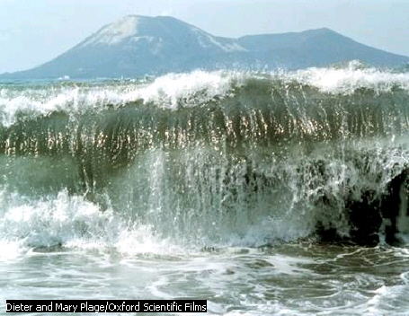 giant
paddle, producing powerful water waves at the ocean surface. The
ocean waves spread out from the vicinity of the earthquake source and
move across the ocean until they reach the coastline, where their
height increases as they reach the continental shelf, the part of the
earth's crust that slopes, or rises, from the ocean floor up to the
land. Tsunamis wash ashore with often-disastrous effects such as
severe flooding, loss of lives due to drowning, and damage to property.
giant
paddle, producing powerful water waves at the ocean surface. The
ocean waves spread out from the vicinity of the earthquake source and
move across the ocean until they reach the coastline, where their
height increases as they reach the continental shelf, the part of the
earth's crust that slopes, or rises, from the ocean floor up to the
land. Tsunamis wash ashore with often-disastrous effects such as
severe flooding, loss of lives due to drowning, and damage to property.
Earthquakes can also cause water in lakes and reservoirs to slosh back and forth. This sloshing can cause retaining walls and dams to collapse and lead to flooding and damage downstream.
Disease
Catastrophic earthquakes can create a risk of widespread disease outbreaks, especially in underdeveloped countries. Damage to water supply lines, sewage lines, and hospital facilities as well as lack of housing may lead to conditions that contribute to the spread of contagious diseases, such as the flu and other viral infections. In some instances, lack of food supplies, clean water, and heating can create serious health problems as well.
WHAT CAN WE DO TO REDUCE DAMAGE
Earthquakes cannot be prevented, but the damage they cause can be greatly reduced with communication strategies, proper structural design, emergency preparedness planning, education, and safer building standards.
Tsunami early-warning systems can prevent some damage because tsunami waves travel at a very slow speed. Seismologists immediately send out a warning when evidence of a large undersea earthquake appears on seismographs.
Engineers minimize earthquake damage to buildings by using flexible, reinforced materials that can withstand shaking in buildings.
Structural Design
Geologists and engineers use risk assessment maps to understand where faults are located and how to build near them safely.
In urban areas of the world, the seismic risk is greater in non-reinforced buildings made of brick, stone, or concrete blocks because they cannot resist the horizontal forces produced by large seismic waves. Fortunately, single-family timber-frame homes built under modern
Emergency Preparedness Plans
Earthquake education and preparedness plans can help significantly reduce death and injury caused by earthquakes. People can take several preventative measures within their homes and at the office to reduce risk. Supports and bracing for shelves reduce the likelihood of items falling and potentially causing harm. Maintaining an earthquake survival kit in the home and at the office is also an important part of being prepared.
In the home, earthquake preparedness includes maintaining an earthquake kit and making sure that the house is structurally stable. The local chapter of the American Red Cross is a good source of information for how to assemble an earthquake kit. During an earthquake, people indoors should protect themselves from falling objects and flying glass by taking refuge under a heavy table. After an earthquake, people should move outside of buildings, assemble in open spaces, and prepare themselves for aftershocks. They should also listen for emergency bulletins on the radio, stay out of severely damaged buildings, and avoid coastal areas in the event of a tsunami.
In many countries, government emergency agencies have developed extensive earthquake response plans. In some earthquake hazardous regions, such as California, Japan, and Mexico City, modern strong motion seismographs in urban areas are now linked to a central office. Within a few minutes of an earthquake, the magnitude can be determined, the epicenter mapped, and intensity of shaking information can be distributed via radio to aid in response efforts.
THE STUDY OF EARTHQUAKES
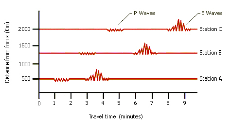
Seismologists measure earthquakes to learn more about them and to use them for geological discovery. They measure the pattern of an earthquake with a machine called a seismograph. Using multiple seismographs around the world, they can accurately locate the epicenter of the earthquake, as well as determine its magnitude, or size, and fault slip properties.
How We Measure Earthquakes
There are more than 1000 seismograph stations in the world. One way that seismologists measure the size of an earthquake is by measuring the earthquake's seismic magnitude, or the amplitude of ground shaking that occurs. Seismologists compare the measurements taken at various stations to identify the earthquake's epicenter and determine the magnitude of the earthquake. This information is important in order to determine whether the earthquake occurred on land or in the ocean. It also helps people prepare for resulting damage or hazards such as tsunamis. When readings from a number of observatories around the world are available, the integrated system allows for rapid location of the epicenter. At least three stations are required in order to calculate the epicenter. Seismologists find the epicenter by comparing the arrival times of seismic waves at the stations, thus determining the distance the waves have traveled. Seismologists then apply travel-time charts to determine the epicenter. With the present number of worldwide seismographic stations, many now providing digital signals by satellite, distant earthquakes can be located within about 6 miles of the epicenter and about 6 to 12 miles in depth.
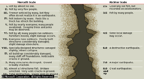
The first widely used seismic magnitude scale was developed by the American seismologist Charles Richter in 1935. The Richter scale measures the amplitude, or height, of seismic surface waves. The scale is logarithmic, so that each successive unit of magnitude measure represents a tenfold increase in amplitude of the seismogram patterns. This is because ground displacement of earthquake waves can range from less than a millimeter to many meters. Richter adjusted for this huge range in measurements by taking the logarithm of the recorded wave heights. So, a magnitude 5 Richter measurement is ten times greater than a magnitude 4 and 100 times greater than a magnitude 3 measurement.
Today, seismologists prefer to use a different kind of magnitude scale, called the moment magnitude scale, to measure earthquakes. It is more reliable for earthquakes that measure above magnitude 7 on other scales. The moment magnitude of the 1906 San Francisco earthquake was 7.6; the Alaskan earthquake of 1964, about 9.0; and the 1995 Kôbe, Japan, earthquake was a 7.0 moment magnitude; in comparison, the Richter magnitudes were 8.3, 8.6, and 6.8, respectively for these tremors.
Science is still trying to Predict Earthquakes
Seismologists try to predict how likely it is that an earthquake will occur, with a specified time, place, and size. Earthquake prediction also includes calculating how a strong ground motion will affect a certain area if an earthquake does occur. Scientists can use the growing catalogue of recorded earthquakes to estimate when and where strong seismic motions may occur. They map past earthquakes to help determine expected rates of repetition. Seismologists can also measure movement along major faults using global positioning satellites (GPS) to track the relative movement of the rocky crust of a few centimeters each year along faults.
The elastic rebound theory gives a generalized way of predicting earthquakes because it states that a large earthquake cannot occur until the strain along a fault exceeds the strength holding the rock masses together.
The Study of Earthquakes has given us a look at Earth's Interior
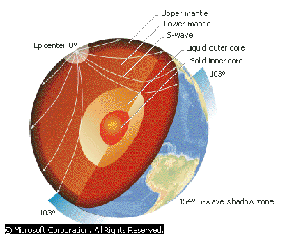
Seismologists also study earthquakes to learn more about the structure of the earth's interior. Earthquakes provide a rare opportunity for scientists to observe how the earth's interior responds when an earthquake wave passes through it. Measuring depths and geologic structures within the earth using earthquake waves is more difficult for scientists than is measuring distances on the earth's surface. However, seismologists have used earthquake waves to determine that there are four main regions that make up the interior of the earth: the crust, the mantle, and the inner and outer core.
The intense study of earthquake waves began during the last decades of the 19th century, when people began placing seismographs at observatories around the world. By 1897, scientists had gathered enough seismograms from distant earthquakes to identify that P and S waves had traveled through the deep earth. Seismologists studying these seismograms later in the late 19th and early 20th centuries discovered P wave and S wave shadow zones-areas on the opposite side of the earth from the earthquake focus that P waves and S waves do not reach. These shadow zones showed that the waves were bouncing off some large geologic interior structures of the planet.
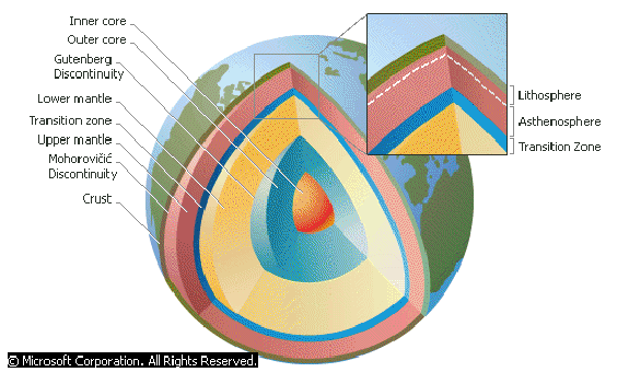
Seismologists used these measurements to begin interpreting the paths along which the earthquake waves traveled. In 1904 Croatian seismologist Andrija Mohorovi?iæ showed that the paths of P and S waves indicated a rocky surface layer, or crust, overlying more rigid rocks below. He proposed that inside the earth, the waves are reflected by discontinuities, chemical or structural changes of the rock. Because of his discovery, the interface between the crust and the mantle below it became known as the Mohorovi?iæ, or Moho Discontinuity.
In 1906 Richard Dixon Oldham of the Geological Survey of India used the arrival times of seismic P and S waves to deduce that the earth must have a large and distinct central core. He interpreted the interior structure by comparing the faster speed of P waves to S waves, and noting that P waves were bent by the discontinuities such as the Moho Discontinuity. In 1914 German American seismologist Beno Gutenberg used travel times of seismic waves reflected at this boundary between the mantle and the core to determine the value for the radius of the core to be about 3500 km (about 2200 mi). In 1936 Danish seismologist Inge Lehmann discovered a smaller center structure, the inner core of the earth. She estimated it to have a radius of 1216 km (755 mi) by measuring the travel times of waves produced by South Pacific earthquakes. As the waves passed through the earth and arrived at the Danish observatory, she determined that their speed and arrival times indicated that they must have been deflected by an inner core structure. In further studies of earthquake waves, seismologists found that the outer core is liquid and the inner core is solid.
MOON QUAKES AND QUAKES ON OTHER PLANETS
Seismic events similar to earthquakes also occur on other planets and on their satellites. Scientific missions to Earth's moon and to Mars have provided some information related to extraterrestrial quakes. The current Galileo mission to Jupiter's moons may provide evidence of quakes on the moons of Jupiter.
Between 1969 and 1977, scientists conducted the Passive Seismic Experiment as part of the United States Apollo Program. Astronauts set up seismograph stations at five lunar sites. Each lunar seismograph detected between 600 and 3000 moonquakes every year, a surprising result because the moon has no tectonic plates, active volcanoes, or ocean trench systems. Most moonquakes had magnitudes less than about 2.0 on the Richter scale. Scientists used this information to determine the interior structure of the moon and to examine the frequency of moonquakes.
Besides the moon and the earth, Mars is the only other planetary body on which seismographs have been placed. The Viking 1 and 2 spacecraft carried two seismographs to Mars in 1976. Unfortunately, the instrument on Viking 1 failed to return signals to earth. The instrument on Viking 2 operated, but in one year, only one wave motion was detected. Scientists were unable to determine the interior structure of Mars with only this single event.
Contributed By: Bruce Bolt